Written by Jawwad Nafees (Managing Director, jn trekkers club)
Every hiker and trekker have a dream in their life that they must trek to K2 basecamp. But only a lucky few manage to do this trek. There are many reasons for this. The main reason being the expenses involved in this trek. Because this trek is unique from normal treks and unique things are expensive. This trek is also unique from normal treks because it is a very long trek. Usually the treks that are done are not more than 4 or 5 days but it takes you 7 to 8 days to reach the basecamp and at least 5 days for the return. So, in total this trek becomes 12 to 13 days. And if the weather turns bad, it takes more days. Those who have some buffer time, they sit and wait for the weather to improve. But some, who come from job or business or cannot stay longer due to household responsibilities return disappointed. There are many such stories of tourists heading to K2 basecamp and unable to complete the trek due to inclement weather.
Since the trek is long, many people get sick on reaching the basecamp, dehydration, vomiting, motion sickness, fever due to fatigue, etc. People come back from the road. There are no medical facilities throughout the trek, you have to be brave and keep yourself healthy. The rest of the treks are short and you can do the return comfortably, but even coming back from the route on this trek is like a torture. One is bad health and the other is the disappointment of not completing the trek. So, it is very important that when you leave for the basecamp tour, pray to Allah that the weather will be pleasant and the conditions will be favorable, and that you will complete the trek safely. And come back with lots of memories.
From your Home to Skardu
Journey of K2 starts at least 6 months before the original date. As you gather information about the trek, prepare the equipment list, purchase the equipment and start the workout for this trek. Try to find time out of your busy schedules. If you do a job, you take a vacation. You leave home with full enthusiasm, and reach Skardu. There are 3 ways to reach Skardu either by air, by road or by adventure on your bike. Most of the people come by air because it is nice and comfortable. The farther your city is from Skardu, the more it takes to reach Skardu. It is better that you come by air. So far Skardu Airport has been given the status of International Airport, In sha Allah very soon international flights will start arriving here. In Skardu you see a lot of foreign tourists, they have to come to Islamabad first and then take a flight from there to Skardu. In the coming days they will be able to come directly to Skardu. Another thing to keep in mind is “plan B”. This means that beyond Islamabad the mountain ranges almost start, and the weather in the mountains is very uncertain. If it is sunny now, suddenly clouds will come and rain, the weather will be bad. Flights are often canceled due to this uncertain weather. It is not necessary that the weather is fine in Islamabad or Skardu, the entire route must be clear. It is also your luck that your flight is not canceled and you reach Skardu by air. Otherwise, you should have a plan B, i.e. the by-road option. Skardu is at least 2 days journey from Islamabad. Therefore, you should plan accordingly so that if the flight is canceled and you have to go by road, you reach on time.
Arriving at Skardu, beautiful views are in front of you. Perhaps this airport is the smallest, simplest and most beautiful airport in the world because it is built in a desert called Katapna Desert. A desert at an altitude of 2,500 meters and an airport in the desert is a wonderful sight when you step out of the plane. Your photography starts as soon as you step out of the plane. You get out and reach the hotel looking at the beautiful scenery. One to two days you have to stay in a hotel, to familiarize yourself with the environment, meet the new members, and buy any equipment for the trek. Since it is a long trek, so it is not done in too much of a hurry that you reach Skardu and immediately leave for the trek. After reaching the hotel, your tour operator or guide takes your ID cards or passport from you and get NOC. It is very important to get NOC to go on this trek because it is a restricted area which is located on the Pakistan-China border, so every visitor must have NOC. It is the responsibility of the tour operator and it is included in the package to arrange the NOC. The night before starting the trek, the tour operator gathers all the people at one place and gives full awareness about the trek. Describes packing arrangements and safety precautions. Usually you guys know everything because you have been preparing for the last 6 months but still it is the responsibility of the tour operator.
Skardu to Askole (130 KM jeep ride)
The next day, which I call the second day of the tour, is when you leave the Skardu hotel for the first destination, the Askole. You exit the hotel and the jeep is waiting for you. You hand over your belongings to the guide so they can load them into the jeep. In such a while you have breakfast and get ready. You’re going to travel by jeep today, so dress casually, don’t overpack yourself. All you need is your mobile or camera. Before leaving the hotel, check your room thoroughly to ensure that no belongings have been left behind. And before sitting in the jeep, make sure that you have loaded all the stuff. In the excitement of trek, taking photographs or making their v-logs, people forget to check their luggage and sometimes blame it later. Actually, it is only your responsibility to take care of your own luggage. The journey starts from Skardu, the road is excellent and you enjoy a lot. Distance from Skardu to Askole is 130 KM according to google map. And it took us about 7 hours to reach here.
Sarfaranga Desert and Bab-e Shigar
On the way, you have to pass through the Sarfaranga desert. The Sarfaranga desert, also known as the cold desert, is located at an altitude of 7,500 feet. Its distance from Skardu city is 16 KM and it takes only 30 minutes to reach here. I suggest you stop here for 15 minutes, take photos and videos. Once a year a jeep rally is also organized here and many enthusiasts visit here. There are also para-motoring, jeep riding, and horse riding. If you have time, you must enjoy para-motoring. Here you will see a gate called Bab-e Shigar. That is, the entrance to Shigar district. If this door is described in simple words, then you can say that after entering this door, the highest peaks of the world will be in front of you, which includes K2, Mitre peak, Broad peak etc.
Hashopi Gardens
On the same route, you will also get to see Hashopi Gardens. There are apples, and apricot orchards that are of interest to tourists. An exhibition is also held at Hashopi Gardens where people display their garden produce. And people from all over Pakistan come and shop here. These products include varieties of apples, apricots, apple jams, apricot jam, etc.
Dasu Lunch site
After a drive of about 3 hours you reach Dasu, enjoying the Indus River, and the beautiful hills. Lunch is served here. People pray, wash their hands and freshen up. Take off your shoes and walk on the cool grass to relax your feet. After one and a half hours, the journey starts again. On the way you see mountains in which you see many cave-like holes. These are actually mining holes. Workers are working here who extract precious stones from these caves and then sell them. It is not known whether this work is being done by the government or a private company. Information about where his revenue is going is not available. If the road is perfect, you go straight to Askole and brake. If the road is bad, for example, a road is closed due to a landslide or a bridge is broken due to a flood, you have to walk some distance. After crossing the bad part another jeep is waiting for you. The cargo is unloaded and the rest of the journey is completed.
Askole (3,050 meter)
Askole is the last village of Pakistan in the north. There is no population beyond this village. Because after walking a little further, the series of glaciers starts and there is no population on the glaciers. You will see tourists, porters, and mules on this route. Apart from this, you will not see any animals here except chickens and goats. They are also the ones who walk with you and one day or the other you have to eat them. Since the Askole is populated, there are also shops, you can get food and drinks from here. Further, since the goods have to be carried by the porters, as soon as they see the jeep, the porters gather around the jeep for their work. Some permanent staff of the tour operator walks with them from Skardu. The rest of the porters are taken from here. Porters also have a baggage limit. So, tour operators already limit you how much your baggage should be. Because for extra luggage either you have to take the porter separately or someone else has to pay extra. According to the instructions of the guide you have to carry 2 parts of your luggage. A bag will carry your porter which should weigh 12 KG. And you will carry a backpack yourself, the lower the weight, the better for you. If your luggage is more than 12 KG, you may have to pay extra. Its charges vary from time to time. As I am writing this, you have to pay Rs 1,000 per KG for the entire tour. That is, if the weight of your luggage becomes 13 kg, then you will have to pay 1,000 rupees extra. If your gear is essential and will be of use to you on the trek, then you should pay extra.
On reaching the Askole, the kitchen staff sets up their kitchen tent and first arranges tea for you. Meanwhile, the rest of the staff i.e. the porters prepare your camp so that you can store your luggage, rest, change clothes. There are two persons in a camp. Camp and mats are provided by the company, while the sleeping bag is your own. The tea is ready by the time you freshen up. You sit in the kitchen tent chatting and enjoying tea. After taking tea, you take a look around. You share your stories with each other. It’s late at night and once again you gather in the kitchen tent and eat dinner. The guide informs you about the next day and asks you to rest so that you are refreshed for the next day.
Askole Museum
There is a small museum built in a house in the Askole, where some memorabilia of old times are kept like some old weapons, some books, old utensils, etc. If you reach the Askole, you must visit this house. The house also has a basement, which is said to be where people go underground when it gets very cold and shift the entire system downstairs to stay warm.
Askole to Jhola (3,200 meters)
In the past, tourist trekking used to start from Askole. But now a jeep trek has been made from Askole to Jhola. But if there is a landslide or road block for some reason, then your trekking starts from today itself. The route from Askole to Jhola is about 18 KM and it becomes a 6 to 7 hour trek. This trek is easy because you don’t have to hike much. You walk towards your destination enjoying the views. After about 1 hour comes the Central Karakoram Check Post (CKNP). Where you have to fill an entry form. Here you write down, where you are going and for what purpose you are going. In this office you also get to see a map of the entire area which gives you an idea of what points are on your way and much more information. The entry fee is 2,400 rupees for Pakistani tourists and 150 US dollars for foreign tourists, which is paid by tour operator. More details are as follows.

After filling entry form, you resume your trekking. As today’s trek is easy, it doesn’t matter much whether the weather is cold or hot. Next to you flows the waters of the Baltoro Glacier, also known as the Baltoro River. Further along comes a bridge, which this year was exposed to floodwaters and you would need a dolly (swing) to cross it. Some people also call it Jhola (swing). But in general terms, it is a kind of chairlift, with the help of which you cross this small but fast-flowing river. The width of this river is not much but the flow is so fast that you cannot take the risk of crossing it. This lift is built by the local people under self-help. There is a person on both sides who takes turns to make people cross the river from each side. Since only one person can go from one side to the other at a time, a lot of time is lost here. Well, if you cross this river and go ahead, today’s lunch site comes. It takes 3 hours from Askole to reach here if there are no obstacles on the way. The kitchen staff is already there and preparing lunch for us. It is the responsibility of the kitchen staff to arrive everywhere before us, so that the kitchen tent is ready and the food is ready by the time we arrive. They are local people, they are used to hard work, they can bear hunger too. But we trek very often, we are tired and impatient. We need something to eat immediately to restore our energy. On the way you will get only glacier water to drink. There are very few natural springs here. Most of the water that will be found along the way will be from these glaciers or snow on the mountains. Some people can digest this water. But most people get upset stomach. Most people ask the kitchen staff to boil water for them. Some people also keep medicines to purify the water. So, water is the most precious thing on this trek and you have to use it carefully. Have at least a 1-liter bottle with you which you use slowly.
From the lunch site again, you start your trek and on the way, you have to cross another bridge called Snow Leopard Bridge. This bridge is the sign of Jhola campsite. It means that today’s destination has arrived. This campsite is not a good campsite. Just understand that there are thorn bushes in the desert and this is where you have to spend the night. Each campsite is selected near the water so that it is convenient for the cooks and if one has to go to the toilet, it is also convenient for him. The weather gets colder at night so use warm clothes. Caution is very important because if you get sick you will not be able to complete the trek.
Jhola/Jhula to Paiju (3,450 meter)
Today is the fourth day of your tour and today is one of the tough days. Today’s trek is long and tiring. The distance from Jhola to Paiju is 22 KM and it takes 7 to 8 hours to reach the Paiju campsite. The reason for the difficulty of this trek is that you have to hike a lot. You have to cross streams with fast flowing water. If the weather is good, the feeling of fatigue is less but if the sun is overhead, this trek becomes more difficult. Drink water frequently, rest, and then trek makes it long. And you just think at every step how much journey is left. In the beginning everyone starts together but then the distance increases due to fatigue. Some are walking in pairs and some are left alone. After walking for 4 and a half hours, Bardomal lunch site is reached, where lunch is served. Local people have tried to improve this site a little. Some rooms and some washrooms are made of stones. After lunch, when we walk further, we have to pass through the sand field. Sand and thorn bushes. It doesn’t seem like you’re heading for mountains with tons and tons of snow. It seems like you are walking in a desert of Cholistan. As you walk, you come across Paiju Peak which is 6,610 meters high. Another fun thing is that the porters you accompany only know the names of these peaks, but they don’t know what the actual peak is. Few people identify the actual peak. This is also because every year there are new porters who do not know. Frequent porters and especially porters who come with foreigners are quite knowledgeable as foreigners come after much research. They know more details of the entire trek than the locals. The hike comes up which looks pretty tough. After the hike you see the board of Paiju campsite, but surprisingly the Paiju campsite still doesn’t come. Seeing the board would have been reassuring that we have reached but it is nothing but a hoax. You still have to walk. The trek never ends. Anyway you reach the Paiju campsite. This campsite is a much better campsite than the Jhula campsite. It has good water management. Fiber portable washrooms are installed. There is no cleaning system for the washrooms. Better to find a rock and relieve yourself there. The porters have arrived, the camp is ready. The kitchen staff is busy cooking food. Since this is a tiring trek and the next day’s trek is also long and difficult, most of the tour operators stay here for a day. And some spend the night and go ahead.
Paiju to Khuburse (3,834 meter)
Today’s trek is only 15 KM but very tiring. Because from here the Baltoro Glacier starts. When you hear the glacier, it comes to mind that there will be a snowy trek and you have to trek on snow. But this is not the case because the glacier continues to melt, and as it melts, rocks slide down from the mountains. You won’t see snow anywhere, only dirt and rocks all around.
Baltoro Glacier
The Baltoro Glacier is one of the longest glaciers outside the polar region. It is 63 kilometers long and approximately 2.1 kilometers wide.
Lily Go Campsite
Today’s trek is also 7 to 8 hours, but becomes longer and more difficult due to walking on rocks. Sudden ups and downs, the whole way is like that. Since the glacier is constantly melting, every year you visit it, you will see a change. Especially the trek has changed. So, it is very important that you stay with your group and the guide. If you go on the wrong trek, you may go too far and face a deep crevasse and get lost. Then you have to go back to get back on the original trek. The guide knows which way is safe and where to step. Walking on the glacier is very risky, so you need to be very careful. Even though you are walking on the glacier, you do not get water to drink. If you run out of water, it’s a big problem. You can see the water, but you won’t be able to get there because you’ll be tired anyway. Somewhere if you get clean drinking water, then your happiness is endless. After 5 hours of trek, Lily Go campsite is reached where lunch is served. Noodles or vegetable soup is very useful for lunch. It gives you energy at once. Apricot is very useful in this trek, it also acts as an energy booster, so apricot is a must have for you.
After lunch you start your journey again. All the trek you find sand and stones. Let me tell one more thing here that a black wire runs with you from Askole to Concordia. This black wire is installed by the people of Central Karakoram National Park. This string indicates whether you are in the right direction or not. Remember to keep an eye on this black wire whenever you trek and look for it if you stray from the trek. You have to cross a river a few meters before reaching the Khuburse campsite. As the evening progresses, the water of this river becomes faster. So, it has to be crossed very carefully. Try to stay with the porter and guide so that they can rescue you if you slip. After crossing the river, there is a sand climb immediately after which comes the good camp site. There is a stone washroom. Water is provided for bathing. If the weather is fine, that means the sun has come out, then you should take a bath and freshen up. But if the weather is cold, don’t take this risk. Wash your hands, eat food and rest.
Khuburse to Urdukas (3,990 meter)
Today is your sixth day. Today is a little hard, but more easy. Hard because there is a very difficult hike as the trek starts. And easy because today you only have to walk for 2-3 hours and only 5 KM. Today, your direct destination is Urdukas. Today there is no stopping at the lunch site. After about an hour you see the green mountains and plants that make your heart happy. Taking photos and videos, you arrive at the Urdukas campsite. Today you have the whole day to relax. Here also you can find portable fiber washrooms but they are not clean. Bathing facilities are also available here. There are basins for washing hands and mouths. There is a huge rock on which you can climb and have a view of the whole area. Tourists sit here for a long time. The porters are also quite relaxed and sing and dance when they are done with their work. This trek gives you a view of the famous Trango Towers, and Uli Biaho (6,109 m).
Trango Towers
Trango Towers is a family of rock towers located in Gilgit-Baltistan, northern Pakistan. These towers are the largest rocks in the world and are very difficult to climb. Every year, many expeditions from different countries of the world come to climb these difficult rocks. The highest point in the family is the 6,286 m (20,623 ft) summit of Trango Tower, whose east face is the largest near-vertical drop in the world.
Urdukas to Goro II (4,380 meter)
The distance from Urdukas to Goro 2 is 10 KM and even today you have to trek for 6 to 7 hours. Today’s trek is relatively easy. In today’s trek you will see snow in places. Today you will really feel like you are trekking on a glacier. After 3 hours of trek you reach the lunch site which is called Goro 1. Here you can see the famous peak Masherbrum also known as K-1. At 7,821 meters high this peak is the 22nd highest peak in the world and the ninth highest peak in Pakistan.
After lunch the journey starts again and after 4 hours you reach the destination i.e. Goro 2. Today you have to sleep on the glacier. Before today, the camps were set up away from the glacier, but today you have no place to stay away from the glacier. Today, all around you, there are snow-capped mountains and snow below. For today and the days ahead you should have a good sleeping bag and an extra sleeping mat. A double sleeping mat will keep you away from the cold. You are now at a high altitude. The oxygen level is very low. Many people feel suffocated due to not being able to breathe while sleeping in the camp at night. In such a case, you should keep the zipper or the window of your camp open so that the air can cross. Try to go back to sleep after breathing is restored. No need to worry, this is normal which happens due to lack of oxygen.
Goro II to Concordia (4,620 meters)
After breakfast you start your journey towards your destination for which you have prepared so much. That means today you will be lucky to see K2. Today’s trek is 12 KM long and today’s trekking is also 6 to 7 hours long. But today’s trek is very beautiful. Beautiful snow-covered rocks, can be seen on the way. The beautiful water of the glacier, and all the lofty peaks that you have only heard about, slowly get closer to you. On the way you get a view of Muztagh tower which is 7,276 meters high. After walking for three hours you reach Concordia Mor which is today’s lunch site. After lunch you walk again. After another hour of walking, the check post of Pakistan Army is reached where very loving soldiers are protecting this country.
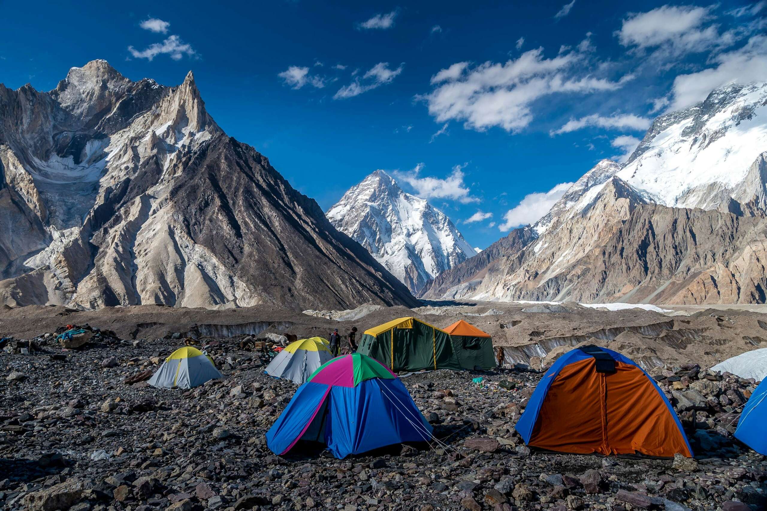
Concordia (4,620 meters)
Finally, you reach your destination, Concordia, and the world’s highest peaks are in front of you. It’s strange that even from where sign board of Concordia is installed, you can’t see K2. K2 is such a cruel mountain. People come from far and wide to see it and it doesn’t make its appearance before a special point. From the signboard of Concordia, marble pack is visible on the right hand side. You have to walk a little further. K2 will be watching you from behind the marble pack, and as soon as you see him, you will be overjoyed. You will thank to Allah that He has blessed you with good health. Tour operators refer to Concordia as their K2 base camp. They say that this is the base camp for those who come only for trekking. But those who come to summit K2, have to trek for another 6 to 8 hours to reach the next base camp. It is the choice of the tourist whether they want to sit here and see the K2 or go to the next base camp.
Many people get sick on arrival here. The water here, or storage, is not available to everyone, due to which many problems like vomiting, motion, dehydration etc. are caused. The rescue operation from the army is very expensive and it is also a difficult procedure. Foreign tourists leave after getting their insurance, but this habit is not found among Pakistani tourists. The reason for this is that insurance is also very expensive. Sitting at this point there are many famous peaks in front of you including Mitre Peak (6,010 m), Marble Peak (6,256 m), K2 (8,611 m), Broad Peak (8,051 m), Gasherbrum (7,925 m), besides Baltoro Kangri, Chogo Lisa etc. Each peak has some name. But still many peaks are unnamed. Tourists stay for one day at Concordia. Relieves fatigue and then returns with many memories.
0 Comments
Sol Ogara
Your style is very unique in comparison to other people I have read stuff from. Many thanks for posting when you have the opportunity, Guess I’ll just book mark this blog.
Jawwad Nafees
Thank you Sol Ogara . If you want to visit contact us +92 336 4237616
Mana Merlos
You’ve made some decent points there. I checked on the internet to learn more about the issue and found most individuals will go along with your views on this site.